


Voting Districts not defined, Gogebic County, Michigan
About
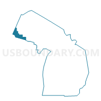
Outline

Summary
| Unique Area Identifier | 596692 |
| Name | Voting Districts not defined |
| County | Gogebic County |
| State | Michigan |
| Area (square miles) | 332.62 |
| Land Area (square miles) | 0.00 |
| Water Area (square miles) | 332.62 |
| % of Land Area | 0.00 |
| % of Water Area | 100.00 |
| Latitude of the Internal Point | 46.79151160 |
| Longtitude of the Internal Point | -90.14115430 |
Maps


Graphs
Select a template below for downloading or customizing gragh for Voting Districts not defined, Gogebic County, Michigan


Neighbors
Neighoring Voting District (by Name) Neighboring Voting District on the Map
- Voting District 0534108000001, Gogebic County, MI
- Voting District 0538280000001, Gogebic County, MI
- Voting District 1311352000001, Ontonagon County, MI
- ANDERSON - T 9999 Voting District, Iron County, WI
- SAXON - T 1 Voting District, Iron County, WI
- WATER Voting District, Ashland County, WI
- Voting Districts not defined, Ontonagon County, MI
Top 10 Neighboring County Subdivision (by Population) Neighboring County Subdivision on the Map
- Ironwood charter township, Gogebic County, MI (2,333)
- Carp Lake township, Ontonagon County, MI (722)
- Saxon town, Iron County, WI (324)
- Wakefield township, Gogebic County, MI (305)
- County subdivisions not defined, Ashland County, WI (0)
- County subdivisions not defined, Ontonagon County, MI (0)
- County subdivisions not defined, Iron County, WI (0)
- County subdivisions not defined, Gogebic County, MI (0)
Top 10 Neighboring Unified School District (by Population) Neighboring Unified School District on the Map
- Ironwood Area Schools, MI (8,046)
- Hurley School District, WI (4,219)
- Wakefield-Marenisco School District, MI (3,883)
- Ontonagon Area Schools, MI (3,632)
- White Pine School District, MI (722)
- School District Not Defined (Water), WI (0)
Top 10 Neighboring State Legislative District Lower Chamber (by Population) Neighboring State Legislative District Lower Chamber on the Map
Top 10 Neighboring State Legislative District Upper Chamber (by Population) Neighboring State Legislative District Upper Chamber on the Map
Top 10 Neighboring 111th Congressional District (by Population) Neighboring 111th Congressional District on the Map
Top 10 Neighboring Census Tract (by Population) Neighboring Census Tract on the Map
- Census Tract 9507, Gogebic County, MI (2,402)
- Census Tract 9703, Ontonagon County, MI (2,033)
- Census Tract 1802, Iron County, WI (1,493)
- Census Tract 9900, Iron County, WI (0)
- Census Tract 9900, Ashland County, WI (0)
- Census Tract 9901, Ontonagon County, MI (0)
- Census Tract 9900, Gogebic County, MI (0)